


Roussillon granges de la brasque Roussillon

sylvainstaels
User
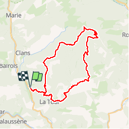

Length
39 km

Max alt
2014 m

Uphill gradient
2380 m
Km-Effort
70 km

Min alt
352 m

Downhill gradient
2379 m
Boucle
Yes
Creation date :
2019-01-15 12:13:45.806
Updated on :
2019-01-15 12:13:45.806
4h20
Difficulty : Difficult

FREE GPS app for hiking
 SityTrail
IGN / Geographical institutes
SityTrail Plus
The world is yours!
About
Trail Mountain bike of 39 km to be discovered at Provence-Alpes-Côte d'Azur, Maritime Alps, La Tour. This trail is proposed by sylvainstaels.
Positioning
Country:
France
Region :
Provence-Alpes-Côte d'Azur
Department/Province :
Maritime Alps
Municipality :
La Tour
Location:
Unknown
Start:(Dec)
Start:(UTM)
352261 ; 4869119 (32T) N.
Comments